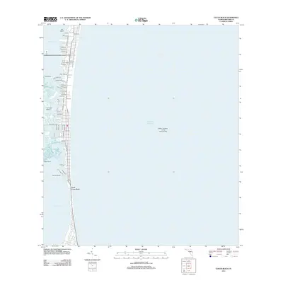
2012 Map of Cocoa Beach
USGS Topo · Published 2012About this map
South Cocoa Beach and the thin barrier island of the Space Coast are documented here in the early 2010s, showing a densely developed residential corridor sandwiched between the Atlantic Ocean and the complex wetlands of the Banana River. The western shoreline is defined by a maze of natural and man-made waterways, including Houseboat Cut, Jones Creek, and the intricate archipelago of the Thousand Islands. Residential naming conventions reflect a mid-century tropical aesthetic with streets like Bimini Rd, Bahama Blvd, and Antigua Dr extending toward the river. Off the coast, the Walter L Hudson, Junior Artificial Reef indicates modern marine conservation efforts. This map reveals the high degree of coastal engineering required to support habitation in this low-lying environment, from the Minutemen Cswy to the various canal-front properties near Shortys Pocket and Shortys Banks.
Find a feature on this map
56 named features on this map. Tap any name to fly to it.
Don’t see what you’re looking for? This feature index may not catch every label — zoom into the map to look around manually.
Map Details
Editions of this 2012 Cocoa Beach Map
This is the sole edition of this map. No revisions or reprints were ever made.
Other maps of this area

1949 · Courtenay
USGS Topo · 1:24,000

1949 · Eau Gallie
USGS Topo · 1:24,000

1949 · Cocoa
USGS Topo · 1:24,000

1949 · Cocoa Beach
USGS Topo · 1:24,000

1949 · Tropic
USGS Topo · 1:24,000

1951 · Eau Gallie
USGS Topo · 1:24,000

1951 · Cocoa
USGS Topo · 1:24,000

1951 · Courtenay
USGS Topo · 1:24,000
1951 · Cocoa Beach
USGS Topo · 1:24,000
1951 · Cape Canaveral
USGS Topo · 1:24,000