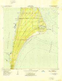
1951 Map of Cape Canaveral
USGS Topo · Published 1951About this map
The Canaveral Peninsula is documented here just before the massive aerospace expansion of the mid-20th century. At this time, the landscape is defined by the U S Coast Guard Reservation and the sprawling De Soto Beach State Game Refuge. Small, isolated settlements like Artesia and Holmes sit along the Banana River, with a local Cem and Artesia P O serving the rural community.
Find a feature on this map
28 named features on this map. Tap any name to fly to it.
Don’t see what you’re looking for? This feature index may not catch every label — zoom into the map to look around manually.
Map Details
Editions of this 1951 Cape Canaveral Map
3 editions found
Other maps of this area

1949 · Orsino
USGS Topo · 1:24,000

1949 · False Cape
USGS Topo · 1:24,000

1949 · Courtenay
USGS Topo · 1:24,000

1949 · Cocoa
USGS Topo · 1:24,000

1949 · Cocoa Beach
USGS Topo · 1:24,000

1951 · False Cape
USGS Topo · 1:24,000

1951 · Cocoa
USGS Topo · 1:24,000

1951 · Courtenay
USGS Topo · 1:24,000
1951 · Cocoa Beach
USGS Topo · 1:24,000

1951 · Orsino
USGS Topo · 1:24,000