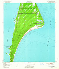
1951 Map of Cape Canaveral
USGS Topo · Published 1987About this map
Cape Canaveral stands as a distinct coastal landmark on this 1951 survey, documented just before the era of space exploration transformed the Florida shoreline. The landscape is dominated by the U S Coast Guard Reservation and the De Soto Beach State Game Refuge, which protected large swaths of the Canaveral Peninsula. Small settlements like Canaveral, Artesia, and Holmes appear alongside the Artesia P O, showing a local community tied to the sea and the Banana River. Navigational landmarks are prominent, including the Cape Canaveral Lighthouse, a Lookout Tower, and various pilings along the coast. The map captures the natural complexity of the bight and the Lighthouse Ponds before massive infrastructure projects altered the topography of the barrier island.
Find a feature on this map
28 named features on this map. Tap any name to fly to it.
Don’t see what you’re looking for? This feature index may not catch every label — zoom into the map to look around manually.
Map Details
Editions of this 1951 Cape Canaveral Map
3 editions found
Other maps of this area

1949 · Orsino
USGS Topo · 1:24,000

1949 · False Cape
USGS Topo · 1:24,000

1949 · Courtenay
USGS Topo · 1:24,000

1949 · Cocoa
USGS Topo · 1:24,000

1949 · Cocoa Beach
USGS Topo · 1:24,000

1951 · False Cape
USGS Topo · 1:24,000

1951 · Cocoa
USGS Topo · 1:24,000

1951 · Courtenay
USGS Topo · 1:24,000
1951 · Cocoa Beach
USGS Topo · 1:24,000

1951 · Orsino
USGS Topo · 1:24,000