
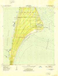
1951 Map of False Cape
USGS Topo · Published 1951About this map
Canaveral Peninsula and the expansive salt marshes of Merritt Island define this coastal landscape at the dawn of the 1950s. The map captures an era of low-density maritime settlement and preservation, featuring the Canaveral Club and a large State Game Refuge that stretches toward the dunes of De Soto Beach. This stretch of the Florida coast, positioned between the Banana River and the Atlantic Ocean, reveals a complex network of estuarine waterways such as Bluebill Creek, Jack Davis Creek, and Pepper Creek. Inland travel is limited to primitive routes like Harrison Road, which provides access to the isolated Harrison Island. Off the coast of False Cape, the shifting sands of Chester Shoal illustrate the navigational hazards that shaped this region's early history.
Find a feature on this map
42 named features on this map. Tap any name to fly to it.
Don’t see what you’re looking for? This feature index may not catch every label — zoom into the map to look around manually.
Map Details
Editions of this 1951 False Cape Map
This is the sole edition of this map. No revisions or reprints were ever made.
Other maps of this area

1949 · Orsino
USGS Topo · 1:24,000

1949 · False Cape
USGS Topo · 1:24,000

1949 · Courtenay
USGS Topo · 1:24,000

1949 · Wilson
USGS Topo · 1:24,000

1951 · Courtenay
USGS Topo · 1:24,000

1951 · Orsino
USGS Topo · 1:24,000
1951 · Cape Canaveral
USGS Topo · 1:24,000

1952 · Wilson
USGS Topo · 1:24,000

1955 · Orlando
USGS Topo · 1:250,000

1957 · Orlando
USGS Topo · 1:250,000