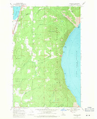
1968 Map of Cocolalla
USGS Topo · Published 1971About this map
Cocolalla Lake and the western shores of Pend Oreille Lake dominate this landscape during the late 1960s, a period where the region's industrial and transit infrastructure remained closely tied to the waterfront. The settlement of Cocolalla serves as a focal point along the western corridor, positioned between the dual rail lines of the Northern Pacific and the Spokane International RR. Local education is centered at Southside Sch, while the interior terrain of the Kaniksu National Forest is marked by steep peaks like Blacktail Mtn and Little Blacktail Mtn. On the eastern shore, the Naval Facility and Evans Landing provide evidence of diverse activity along the deep waters of Pend Oreille. A network of Pack Trails and Jeep Trails penetrates the timbered ridges, passing by landmarks such as Maiden Rock and several unnamed Mines, reflecting the area's legacy of extraction and high-altitude navigation.
Find a feature on this map
30 named features on this map. Tap any name to fly to it.
Don’t see what you’re looking for? This feature index may not catch every label — zoom into the map to look around manually.
Map Details
Editions of this 1968 Cocolalla Map
This is the sole edition of this map. No revisions or reprints were ever made.
Other maps of this area

1901 · Sandpoint
USGS Topo · 1:125,000

1903 · Rathdrum
USGS Topo · 1:125,000

1909 · Cataldo
USGS Topo · 1:125,000

1911 · Cataldo
USGS Topo · 1:125,000

1911 · Priest Lake
USGS Topo · 1:250,000

1911 · Sandpoint
USGS Topo · 1:125,000

1913 · Priest Lake
USGS Topo · 1:250,000

1949 · Packsaddle Mtn
USGS Topo · 1:62,500

1951 · Packsaddle Mtn
USGS Topo · 1:62,500

1955 · Spokane
USGS Topo · 1:250,000