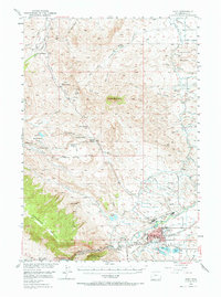
1949 Map of Cody
USGS Topo · Published 1969About this map
The high desert and rugged canyons of Park County define this landscape during the late 1940s, a period when the local economy balanced ranching with early tourism and resource extraction. The city of Cody serves as the regional hub, situated near the dramatic Shoshone Canyon and the eastern edge of the Buffalo Bill Reservoir. The map reveals a complex system of water management essential to the area's development, featuring the Heart Mountain Canal and Cody Canal branching across the arid flats.
Find a feature on this map
55 named features on this map. Tap any name to fly to it.
Don’t see what you’re looking for? This feature index may not catch every label — zoom into the map to look around manually.
Map Details
Editions of this 1949 Cody Map
2 editions found
Other maps of this area

1911 · Oregon Basin
USGS Topo · 1:62,500

1913 · Oregon Basin
USGS Topo · 1:62,500

1949 · Pat O'Hara Mountain
USGS Topo · 1:62,500

1949 · Cody
USGS Topo · 1:62,500

1950 · Clark
USGS Topo · 1:62,500

1950 · Deep Lake
USGS Topo · 1:62,500

1951 · Cody
USGS Topo · 1:62,500

1955 · Cody
USGS Topo · 1:250,000

1957 · Wapiti
USGS Topo · 1:62,500

1957 · Devils Tooth
USGS Topo · 1:62,500