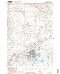
1987 Map of Cody
USGS Topo · Published 1987About this map
The town of Cody sits at a geographic crossroads in Northwest Wyoming where the Shoshone River carves through the landscape. This late-twentieth-century survey reveals a community deeply integrated with its water management and aviation history, featuring a complex network of irrigation infrastructure like the Heart Mountain Canal, Cody Canal, and numerous laterals such as Lateral H-28. The map documents the residential and industrial growth of the city, including a refinery and the E E Faust Regional Airport. Cultural and recreational landmarks are prominent, from the thermal waters at De Maris Springs and the local Golf Course to the Drive-in Theater. The presence of the Burlington Northern railroad and arterial roads like Sheridan Ave underscore the importance of transport in this gateway to the high desert and mountains.
Find a feature on this map
43 named features on this map. Tap any name to fly to it.
Don’t see what you’re looking for? This feature index may not catch every label — zoom into the map to look around manually.
Map Details
Editions of this 1987 Cody Map
This is the sole edition of this map. No revisions or reprints were ever made.
Other maps of this area

1911 · Oregon Basin
USGS Topo · 1:62,500

1913 · Oregon Basin
USGS Topo · 1:62,500

1949 · Cody
USGS Topo · 1:62,500

1951 · Cody
USGS Topo · 1:62,500

1955 · Cody
USGS Topo · 1:250,000

1957 · Devils Tooth
USGS Topo · 1:62,500

1958 · Cody
USGS Topo · 1:250,000

1962 · Cody
USGS Topo · 1:250,000

1966 · Corbett Dam
USGS Topo · 1:24,000
1966 · Vocation
USGS Topo · 1:24,000