Loading...
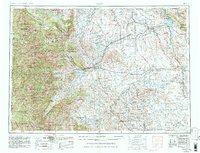
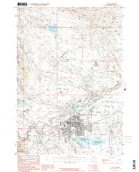
Loading map...1955 Map of Cody
USGS Topo · Published 1980About this map
Cody serves as the gateway to the vast wilderness and high mountain ranges that define this 1955 survey of northwestern Wyoming. The landscape is dominated by the massive Absaroka Range and the high elevations of Younts Peak and Phelps Mountain, while the agricultural heart of the Bighorn Basin is visible to the east. Water management is a central theme, evidenced by the engineering of the Buffalo Bill Dam and the Shoshone Powerplant, which regulate the Shoshone River to support settlements like Powell and Garland.
Find a feature on this map
160 named features on this map. Tap any name to fly to it.
Don’t see what you’re looking for? This feature index may not catch every label — zoom into the map to look around manually.
Map Details
Date Portrayed1955
Date Published1980
PublisherU.S. Geological Survey
Map TypeTopographic
Scale1:250,000
Physical Dimensions28.7 x 22 inches
Editions of this 1955 Cody Map
2 editions found

Historical Maps of Cody Through Time
11 maps found


Featured Locations
Source Details
SourceU.S. Geological Survey
CopyrightPublic Domain