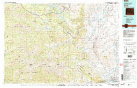
1980 Map of Cody
USGS Topo · Published 1995About this map
Cody serves as the eastern gateway to the high mountain wilderness on this 1980 survey, where the Shoshone River cuts through the dramatic Shoshone Canyon and feeds into the Buffalo Bill Reservoir. The landscape transitions from the developed irrigated flats near the Cody Municipal Airport and Ralston Flats to the high-altitude terrain of the Shoshone National Forest. This map captures a vast system of watersheds and peaks, from the Beartooth Mountains in the north to the North Absaroka Wilderness in the west. Local history is etched into the terrain at the Painter Mine and Pahaska, while geological and recreational features like Heart Mountain and Sweetwater Mineral Springs highlight the diverse environment surrounding the Clarks Fork Yellowstone River. Trails and primitive roads wind through high basins such as Eaglenest Basin and Hoodoo Basin, tracing the reach of early exploration in Park County.
Find a feature on this map
76 named features on this map. Tap any name to fly to it.
Don’t see what you’re looking for? This feature index may not catch every label — zoom into the map to look around manually.
Map Details
Editions of this 1980 Cody Map
3 editions found

Other maps of this area

1885 · Lake
USGS Topo · 1:125,000

1886 · Canyon
USGS Topo · 1:125,000

1891 · Livingston
USGS Topo · 1:250,000

1893 · Livingston
USGS Topo · 1:250,000

1893 · Ishawooa
USGS Topo · 1:125,000

1895 · Ishawooa
USGS Topo · 1:125,000

1895 · Canyon
USGS Topo · 1:125,000

1895 · Lake
USGS Topo · 1:125,000

1896 · Lake
USGS Topo · 1:125,000

1896 · Canyon
USGS Topo · 1:125,000