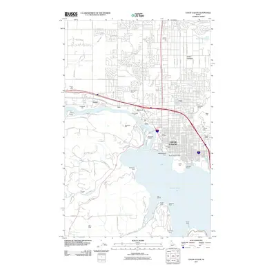
2011 Map of Coeur D'Alene
USGS Topo · Published 2011About this map
Coeur d'Alene sits at the junction of the Spokane River and the lake, serving as a hub of commerce and recreation in northern Idaho. This survey highlights the city's residential expansion into neighboring Dalton Gardens and the industrial corridors following W Seltice Way. The waterfront is densely detailed, featuring infrastructure such as Brooks Seaplane Base and Independence Point, while the surrounding hills like Tubbs Hill and Best Hill define the town's perimeter. Along the river, historical settlement patterns are visible at Gibbs, Blackwell, and Atlas, where the Spokane River (Slu) and Blackwell Slu intersect with former mill and rail sites. Land use varies from the Coeur d'Alene Public Golf Course to agricultural pockets at Mica Flats, illustrating the mix of suburban growth and traditional Idaho landscapes. Local heritage is preserved in numerous burial grounds, including Forest Cemetery and Saint Thomas Cemetery near the lake's edge.
Find a feature on this map
89 named features on this map. Tap any name to fly to it.
Don’t see what you’re looking for? This feature index may not catch every label — zoom into the map to look around manually.
Map Details
Editions of this 2011 Coeur D'Alene Map
This is the sole edition of this map. No revisions or reprints were ever made.
Other maps of this area

1903 · Rathdrum
USGS Topo · 1:125,000

1955 · Spokane
USGS Topo · 1:250,000

1957 · Coeur D'Alene
USGS Topo · 1:62,500

1957 · Lane
USGS Topo · 1:62,500

1958 · Spokane
USGS Topo · 1:250,000

1961 · Hayden
USGS Topo · 1:24,000

1961 · Rathdrum
USGS Topo · 1:24,000

1961 · Spirit Lake
USGS Topo · 1:62,500

1961 · Athol
USGS Topo · 1:62,500

1961 · Hayden Lake
USGS Topo · 1:24,000