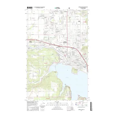
2017 Map of Coeur D'Alene
USGS Topo · Published 2017About this map
Coeur D'Alene sits at the northern edge of Coeur d'Alene Lake, where the Spokane River begins its westward flow toward Post Falls. This modern landscape is defined by the transition from the residential grids of Dalton Gardens and Hayden to the open expanses of the Rathdrum Prairie. Educational and community anchors like N Idaho Coll and Saint Thomas Cem characterize the city's historic core, while natural landmarks such as Tubbs Hill and Sanders Beach frame the shoreline. Along the river, industrial and navigational sites including Blackwell Island and the Spokane River crossings at Atlas and Huetter highlight the area's ongoing role as a regional hub. To the south, the terrain rises into the highlands of Blackwell Hill and the rural stretches of Mica Flats.
Find a feature on this map
208 named features on this map. Tap any name to fly to it.
Don’t see what you’re looking for? This feature index may not catch every label — zoom into the map to look around manually.
Map Details
Editions of this 2017 Coeur D'Alene Map
This is the sole edition of this map. No revisions or reprints were ever made.
Other maps of this area

1903 · Rathdrum
USGS Topo · 1:125,000

1955 · Spokane
USGS Topo · 1:250,000

1957 · Coeur D'Alene
USGS Topo · 1:62,500

1957 · Lane
USGS Topo · 1:62,500

1958 · Spokane
USGS Topo · 1:250,000

1961 · Hayden
USGS Topo · 1:24,000

1961 · Rathdrum
USGS Topo · 1:24,000

1961 · Spirit Lake
USGS Topo · 1:62,500

1961 · Athol
USGS Topo · 1:62,500

1961 · Hayden Lake
USGS Topo · 1:24,000