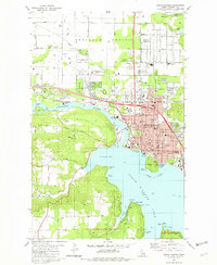
1981 Map of Coeur D'Alene
USGS Topo · Published 1982About this map
The city of Coeur d'Alene serves as the focal point of this 1981 survey, where the urban grid meets the northern shores of Coeur d'Alene Lake. During this era, the landscape shows a mix of established neighborhoods and expanding infrastructure, including Interstate 90 and the Burlington Northern railroad lines. Educational and medical institutions such as North Idaho College and the Kootenai Mem Hospital highlight the town's role as a regional center.
Find a feature on this map
66 named features on this map. Tap any name to fly to it.
Don’t see what you’re looking for? This feature index may not catch every label — zoom into the map to look around manually.
Map Details
Editions of this 1981 Coeur D'Alene Map
2 editions found
Other maps of this area

1903 · Rathdrum
USGS Topo · 1:125,000

1955 · Spokane
USGS Topo · 1:250,000

1957 · Coeur D'Alene
USGS Topo · 1:62,500

1957 · Lane
USGS Topo · 1:62,500

1958 · Spokane
USGS Topo · 1:250,000

1961 · Hayden
USGS Topo · 1:24,000

1961 · Rathdrum
USGS Topo · 1:24,000

1961 · Spirit Lake
USGS Topo · 1:62,500

1961 · Athol
USGS Topo · 1:62,500

1961 · Hayden Lake
USGS Topo · 1:24,000