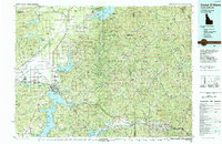
1987 Map of Coeur D'Alene
USGS Topo · Published 1987About this map
Coeur D'Alene Lake dominates the southwestern corner of this landscape, its intricate shoreline carving out Wolf Lodge Bay, Mica Bay, and Cougar Bay. The 1980s saw the region transitioning from its traditional timber and mining roots into a premier residential and recreation hub, visible in the expansion around Post Falls and the residential clusters of Hayden Lake and Dalton Gardens. To the east, the Bitterroot Range and the Coeur d'Alene Mountains create a dense forest environment managed as the Coeur d'Alene National Forest. Transport is anchored by the corridor of Interstate 90, which follows the South Fork Coeur d'Alene River through mining towns like Kellogg and Smelterville. Industrial history is further marked by the presence of Burlington Northern and Union Pacific railroads traversing the Rathdrum Prairie.
Find a feature on this map
101 named features on this map. Tap any name to fly to it.
Don’t see what you’re looking for? This feature index may not catch every label — zoom into the map to look around manually.
Map Details
Editions of this 1987 Coeur D'Alene Map
3 editions found
Other maps of this area

1901 · Sandpoint
USGS Topo · 1:125,000

1901 · Spokane
USGS Topo · 1:125,000

1901 · Coeur D'Alene District
USGS Topo · 1:62,500

1903 · Oakesdale
USGS Topo · 1:125,000

1903 · Rathdrum
USGS Topo · 1:125,000

1903 · Coeur D'Alene District
USGS Topo · 1:62,500

1905 · Oakesdale
USGS Topo · 1:125,000

1906 · Coeur D'Alene District
USGS Topo · 1:62,500

1909 · Cataldo
USGS Topo · 1:125,000

1911 · Cataldo
USGS Topo · 1:125,000