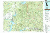
1987 Map of Coeur D'Alene
USGS Topo · Published 1987About this map
Coeur D'Alene Lake and the surrounding peaks of the Bitterroot Range dominate this northern Idaho landscape during the late twentieth century. The map illustrates a complex network of resource extraction and transit, where industrial landmarks like the Sunshine Mine and Bunker Hill Mine sit in the rugged terrain east of Coeur D'Alene. The transition from the steep Coeur D'Alene Mountains to the level Rathdrum Prairie reveals a shifting economy, as old rail lines like the Spokane International and Burlington Northern intersect with the growing suburban footprints of Hayden and Post Falls. Notable heritage sites such as Old Mission State Park and the Farragut State Park (Military Reservation) are clearly delineated, alongside the extensive boundaries of the Coeur D'Alene Indian Reservation and the Kaniksu National Forest.
Find a feature on this map
79 named features on this map. Tap any name to fly to it.
Don’t see what you’re looking for? This feature index may not catch every label — zoom into the map to look around manually.
Map Details
Editions of this 1987 Coeur D'Alene Map
3 editions found
Other maps of this area

1901 · Sandpoint
USGS Topo · 1:125,000

1901 · Spokane
USGS Topo · 1:125,000

1901 · Coeur D'Alene District
USGS Topo · 1:62,500

1903 · Oakesdale
USGS Topo · 1:125,000

1903 · Rathdrum
USGS Topo · 1:125,000

1903 · Coeur D'Alene District
USGS Topo · 1:62,500

1905 · Oakesdale
USGS Topo · 1:125,000

1906 · Coeur D'Alene District
USGS Topo · 1:62,500

1909 · Cataldo
USGS Topo · 1:125,000

1911 · Cataldo
USGS Topo · 1:125,000