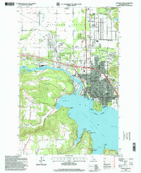
1996 Map of Coeur D'Alene
USGS Topo · Published 1999About this map
Coeur D'Alene serves as the focal point of this late-1990s survey, illustrating a period of significant municipal expansion and infrastructure development where the Spokane River meets the northern shores of Coeur D'Alene Lake. The map details a landscape transitioning from resource-based activity to a more residential and recreational focus, with several Gravel Pits and an Industrial Park positioned near the established community of Dalton Gardens. Institutional and community markers are densely plotted, including North Idaho College, the Kootenai Mem Hosp, and the County Fairgrounds.
Find a feature on this map
71 named features on this map. Tap any name to fly to it.
Don’t see what you’re looking for? This feature index may not catch every label — zoom into the map to look around manually.
Map Details
Editions of this 1996 Coeur D'Alene Map
This is the sole edition of this map. No revisions or reprints were ever made.
Other maps of this area

1903 · Rathdrum
USGS Topo · 1:125,000

1955 · Spokane
USGS Topo · 1:250,000

1957 · Coeur D'Alene
USGS Topo · 1:62,500

1957 · Lane
USGS Topo · 1:62,500

1958 · Spokane
USGS Topo · 1:250,000

1961 · Hayden
USGS Topo · 1:24,000

1961 · Rathdrum
USGS Topo · 1:24,000

1961 · Spirit Lake
USGS Topo · 1:62,500

1961 · Athol
USGS Topo · 1:62,500

1961 · Hayden Lake
USGS Topo · 1:24,000