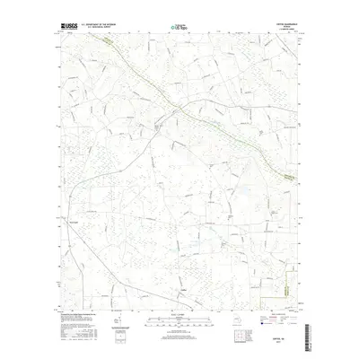
2017 Map of Coffee
USGS Topo · Published 2017About this map
Big Satilla Cr winds through the borderlands of Bacon, Appling, and Pierce counties, defining a landscape shaped by narrow tributaries and small rural settlements. The unincorporated community of Coffee sits in the southern portion of the quadrangle, while New Lacy is positioned to the west along a network of secondary roads. The terrain is largely agricultural and timber-oriented, evidenced by the numerous named rural routes such as Oak Hill Church Rd and Wesley Chapel Church Rd. Significant genealogical detail is preserved through the mapping of small family and community burial grounds, including Wesley Chapel Cem, Moody Cem, and Antioch Cem. These sites, along with Lee Lake and various creeks like Fishing Cr, provide clear landmarks for tracing 21st-century property boundaries and land use patterns in this corner of southern Georgia.
Find a feature on this map
104 named features on this map. Tap any name to fly to it.
Don’t see what you’re looking for? This feature index may not catch every label — zoom into the map to look around manually.
Map Details
Editions of this 2017 Coffee Map
This is the sole edition of this map. No revisions or reprints were ever made.
Other maps of this area

1953 · Waycross
USGS Topo · 1:250,000

1958 · Waycross
USGS Topo · 1:250,000

1971 · Surrency
USGS Topo · 1:24,000

1971 · Coffee
USGS Topo · 1:24,000

1971 · K'ville
USGS Topo · 1:24,000

1971 · Alma NW
USGS Topo · 1:24,000

1971 · Patterson
USGS Topo · 1:24,000

1971 · Alma
USGS Topo · 1:24,000

1971 · Mershon
USGS Topo · 1:24,000
1971 · Alma NE
USGS Topo · 1:24,000