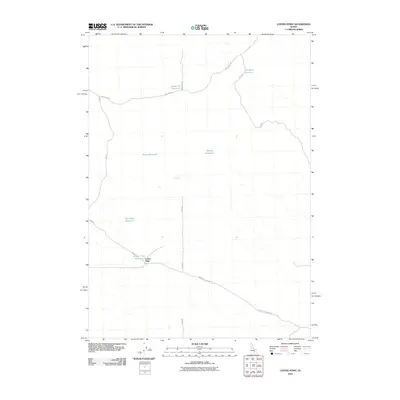
2010 Map of Coffee Point
USGS Topo · Published 2010About this map
Coffee Point and its associated Coffee Point Reservoir anchor this high desert landscape in southeastern Idaho. The area is defined by a sparse network of managed water resources and specialized ranching infrastructure, where water collection is critical to the local economy. A series of small basins, including Sauce Pan Reservoir, Rye Grass Reservoir, Eagle Reservoir, and Ripples Reservoir, are distributed across the terrain to catch seasonal runoff. The human footprint is marked by long, straight utility and access roads such as Springfield Mosby Rd and Well No 2 Rd, which cut through the open spaces of Bingham County. The naming of these water features, particularly Dry Wash Reservoir, reflects the arid nature of the environment and the historical necessity of capturing every possible drop of water for land use.
Find a feature on this map
13 named features on this map. Tap any name to fly to it.
Don’t see what you’re looking for? This feature index may not catch every label — zoom into the map to look around manually.
Map Details
Editions of this 2010 Coffee Point Map
This is the sole edition of this map. No revisions or reprints were ever made.
Other maps of this area

1955 · Idaho Falls
USGS Topo · 1:250,000

1958 · Idaho Falls
USGS Topo · 1:250,000

1972 · Split Top
USGS Topo · 1:24,000

1972 · Mosby Well
USGS Topo · 1:24,000

1972 · Sunset Lake
USGS Topo · 1:24,000

1973 · Rock Butte
USGS Topo · 1:24,000
1973 · Coffee Point SW
USGS Topo · 1:24,000

1973 · Lava Lake Reservoir
USGS Topo · 1:24,000

1973 · Coffee Point NE
USGS Topo · 1:24,000
1973 · Coffee Point
USGS Topo · 1:24,000