1973 Map of Coffee Point NE
USGS Topo · Published 1976About this map
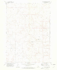
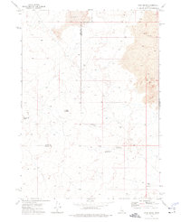
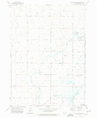
Sheep Lake Reservoir and Duck Lake Reservoir anchor the eastern portion of this high-desert landscape in Bingham County during the early 1970s. This territory is defined by its water management and livestock infrastructure, marked by numerous basins and scattered water sources necessary for ranging in an arid environment. A long Jeep Trail cuts through the northern sections, providing one of the few established routes across the terrain near Camp Reservoir. The map reveals a land geared toward utility, where the distribution of Well sites across the southern and western reaches highlights the critical importance of groundwater access for the ranching operations that have shaped this portion of Idaho. This survey captures a moment before modern development, focusing on the essential hydrological and navigational markers that defined rural life in the region.
Find a feature on this map
5 named features on this map. Tap any name to fly to it.
Don’t see what you’re looking for? This feature index may not catch every label — zoom into the map to look around manually.
Map Details
Editions of this 1973 Coffee Point NE Map
This is the sole edition of this map. No revisions or reprints were ever made.
Other maps of this area
1955 · Springfield NW
USGS Topo · 1:24,000
1955 · Springfield
USGS Topo · 1:24,000

1955 · Idaho Falls
USGS Topo · 1:250,000

1958 · Idaho Falls
USGS Topo · 1:250,000
1973 · Taber
USGS Topo · 1:24,000
1973 · Rock Butte
USGS Topo · 1:24,000
1973 · Coffee Point SW
USGS Topo · 1:24,000
1973 · Lava Lake Reservoir
USGS Topo · 1:24,000
1973 · Coffee Point
USGS Topo · 1:24,000
1973 · Big Fill Reservoir
USGS Topo · 1:24,000