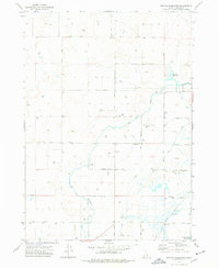
1973 Map of Big Fill Reservoir
USGS Topo · Published 1977About this map
Aberdeen Springfield Canal and its intricate network of laterals dominate this Idaho landscape, illustrating the critical role of irrigation in the Snake River Plain during the early 1970s. The settlement of Grandview serves as a small hub amidst a grid of section lines and secondary roads. The terrain is marked by numerous flowing wells and the Big Fill Reservoir, which facilitate agricultural production in this semi-arid region. In the southeastern corner, the Union Pacific railroad corridor skirts the edge of the American Falls Reservoir, representing the primary transportation artery for moving goods and crops. The map detail extends to functional infrastructure like the Storage Bin and various Borrow Pits, offering a clear view of the rural industrial and water management systems that supported the Bingham County farming community of this era.
Find a feature on this map
13 named features on this map. Tap any name to fly to it.
Don’t see what you’re looking for? This feature index may not catch every label — zoom into the map to look around manually.
Map Details
Editions of this 1973 Big Fill Reservoir Map
This is the sole edition of this map. No revisions or reprints were ever made.
Other maps of this area

1934 · American Falls
USGS Topo · 1:62,500

1934 · Michaud
USGS Topo · 1:62,500

1936 · American Falls
USGS Topo · 1:62,500

1937 · Michaud
USGS Topo · 1:62,500

1954 · Pocatello
USGS Topo · 1:250,000

1955 · Springfield NW
USGS Topo · 1:24,000

1955 · Springfield
USGS Topo · 1:24,000

1955 · Idaho Falls
USGS Topo · 1:250,000

1958 · Idaho Falls
USGS Topo · 1:250,000

1958 · Pocatello
USGS Topo · 1:250,000