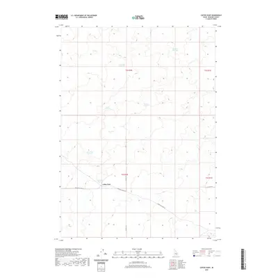
2020 Map of Coffee Point
USGS Topo · Published 2020About this map
Coffee Point stands as a distinct topographical marker in this high-desert landscape of Bingham County, characterized by a sophisticated network of water management features. The area's agricultural and ranching history is etched into the terrain through numerous named catchment sites, including the evocatively named Sauce Pan Reservoir, Eagle Reservoir, and Rye Grass Reservoir. These man-made basins, alongside natural features like Lau Lakes, illustrate a reliance on captured runoff in a region defined by its wide, open spaces. Transport through this territory is focused along Springfield Mosby Rd, which cuts across the central plains near the Coffee Point Reservoir. The map reveals a land divided by the Public Land Survey System, with township and range lines like t2s r30e and t3s r30e framing the sparsely settled desert floor north of the Snake River plain.
Find a feature on this map
16 named features on this map. Tap any name to fly to it.
Don’t see what you’re looking for? This feature index may not catch every label — zoom into the map to look around manually.
Map Details
Editions of this 2020 Coffee Point Map
This is the sole edition of this map. No revisions or reprints were ever made.
Other maps of this area

1955 · Idaho Falls
USGS Topo · 1:250,000

1958 · Idaho Falls
USGS Topo · 1:250,000

1972 · Split Top
USGS Topo · 1:24,000

1972 · Mosby Well
USGS Topo · 1:24,000

1972 · Sunset Lake
USGS Topo · 1:24,000

1973 · Rock Butte
USGS Topo · 1:24,000
1973 · Coffee Point SW
USGS Topo · 1:24,000

1973 · Lava Lake Reservoir
USGS Topo · 1:24,000

1973 · Coffee Point NE
USGS Topo · 1:24,000
1973 · Coffee Point
USGS Topo · 1:24,000