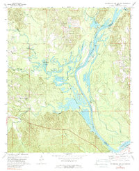
1971 Map of Coffeeville Lock And Dam
USGS Topo · Published 1989About this map
The Tombigbee River forms the central spine of this landscape on the border of Choctaw and Clarke counties, where it is punctuated by a series of landings and riverside infrastructure. At the southern edge of the sheet, the Coffeeville Lock and Dam controls the river's flow, while the Choctaw National Wildlife Refuge preserves the bottomlands and sloughs of the west bank. Local industry is clearly defined by numerous Oil Wells and a Flowing Well scattered near Womack Hill and Barrytown.
Find a feature on this map
49 named features on this map. Tap any name to fly to it.
Don’t see what you’re looking for? This feature index may not catch every label — zoom into the map to look around manually.
Map Details
Editions of this 1971 Coffeeville Lock And Dam Map
2 editions found
Other maps of this area

1953 · Hattiesburg
USGS Topo · 1:250,000

1958 · Hattiesburg
USGS Topo · 1:250,000

1971 · Coffeeville
USGS Topo · 1:24,000

1971 · Ararat
USGS Topo · 1:24,000

1971 · Bladon Springs
USGS Topo · 1:24,000

1971 · Coffeeville Lock And Dam
USGS Topo · 1:24,000

1972 · Tattlersville
USGS Topo · 1:24,000

1972 · Woods Bluff
USGS Topo · 1:24,000

1974 · Millry North
USGS Topo · 1:24,000

1974 · Silas
USGS Topo · 1:24,000