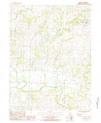
1984 Map of Coffey
USGS Topo · Published 1985About this map
The Grand River meanders across the southern portion of this Daviess County landscape, serving as a primary geographical anchor for the region in the early 1980s. The settlement of Coffey sits in the northeast corner, positioned near the confluence of several vital waterways including Cypress Creek and Little Cypress Creek. This area is defined by its intricate drainage patterns, with Big Creek and Hickory Creek cutting through the terrain. The map documents the rural infrastructure of the era, from the established town grid of Coffey to the Sewage Lagoons on the outskirts, reflecting the modern utility needs of a small Missouri community. The township boundaries of Benton, Salem, and Marion intersect here, showing how local governance and land division were organized around these natural water systems.
Find a feature on this map
11 named features on this map. Tap any name to fly to it.
Don’t see what you’re looking for? This feature index may not catch every label — zoom into the map to look around manually.
Map Details
Editions of this 1984 Coffey Map
This is the sole edition of this map. No revisions or reprints were ever made.
Other maps of this area

1922 · Gallatin
USGS Topo · 1:62,500

1924 · Winston
USGS Topo · 1:62,500

1925 · Pattonsburg
USGS Topo · 1:62,500

1925 · Gilman
USGS Topo · 1:62,500

1944 · Pattonsburg
USGS Topo · 1:62,500

1946 · Gilman
USGS Topo · 1:48,000

1946 · Pattonsburg
USGS Topo · 1:48,000

1948 · Gilman
USGS Topo · 1:62,500

1948 · Pattonsburg
USGS Topo · 1:62,500

1950 · Kansas City
USGS Topo · 1:250,000