
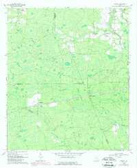
1968 Map of Cogdell
USGS Topo · Published 1970About this map
Cogdell stands at a rural rail-and-road intersection in southeastern Georgia, serving as a primary point of human activity within a landscape dominated by complex wetland systems. The topography is defined by numerous shallow depressions and basins, specifically Huckleberry Bay, Piney Bay, and Greasy Bay, which drain into a network of slow-moving waterways including Suwannee Creek and Perch Creek. This 1960s-era geography reveals a community structured around its spiritual centers, with Zion Hill Ch, Indian Mound Ch, and Hargrave Chapel spaced throughout the countryside.
Find a feature on this map
27 named features on this map. Tap any name to fly to it.
Don’t see what you’re looking for? This feature index may not catch every label — zoom into the map to look around manually.
Map Details
Editions of this 1968 Cogdell Map
2 editions found
Other maps of this area

1953 · Waycross
USGS Topo · 1:250,000

1958 · Waycross
USGS Topo · 1:250,000

1967 · Pine Valley
USGS Topo · 1:24,000

1968 · Homerville East
USGS Topo · 1:24,000

1968 · Manor
USGS Topo · 1:24,000

1971 · Axson
USGS Topo · 1:24,000

1971 · Pearson
USGS Topo · 1:24,000

1971 · Talmo
USGS Topo · 1:24,000

1972 · Sandy Bottom
USGS Topo · 1:24,000
1978 · Homerville West
USGS Topo · 1:24,000