
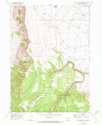
1966 Map of Coglan Buttes SE
USGS Topo · Published 1968About this map
Lake Abert dominates the eastern edge of this high-desert landscape in Lake County, where the water's edge meets the steep slopes of the Coglan Buttes. The hydrology of the mid-1960s is defined by the Chewaucan River, which winds through the central valley toward the Lower Chewaucan Marsh. This area is characterized by drainage patterns including Willow Creek, Juniper Creek, and Crooked Creek, all flowing through a basin marked by an extensive Alkali Flat.
Find a feature on this map
13 named features on this map. Tap any name to fly to it.
Don’t see what you’re looking for? This feature index may not catch every label — zoom into the map to look around manually.
Map Details
Editions of this 1966 Coglan Buttes SE Map
This is the sole edition of this map. No revisions or reprints were ever made.
Other maps of this area

1955 · Klamath Falls
USGS Topo · 1:250,000

1958 · Klamath Falls
USGS Topo · 1:250,000

1964 · Valley Falls
USGS Topo · 1:24,000

1964 · Clover Flat
USGS Topo · 1:24,000

1966 · Coglan Buttes NE
USGS Topo · 1:24,000

1966 · Tucker Hill
USGS Topo · 1:24,000

1966 · Coglan Buttes
USGS Topo · 1:24,000

1968 · Lake Abert North
USGS Topo · 1:24,000

1968 · Lake Abert South
USGS Topo · 1:24,000
1968 · Little Honey Creek
USGS Topo · 1:24,000