
1968 Map of Lake Abert South
USGS Topo · Published 1972About this map
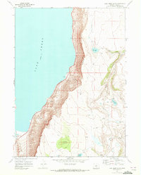
The dramatic precipice of the Abert Rim dominates this 1960s survey of Lake County, dropping sharply from high timbered plateaus toward the alkaline waters of Lake Abert. This high-desert landscape is defined by its verticality and scarce water sources, where family-named landmarks like Johnson Ranch and the Chewaucan River mark the few habitable pockets at the base of the escarpment. The drainage pattern is distinctive, with seasonal flows like Juniper Creek and Poison Creek carving through the rimrock.
Find a feature on this map
23 named features on this map. Tap any name to fly to it.
Don’t see what you’re looking for? This feature index may not catch every label — zoom into the map to look around manually.
Map Details
Editions of this 1968 Lake Abert South Map
2 editions found
Other maps of this area

1955 · Klamath Falls
USGS Topo · 1:250,000

1958 · Klamath Falls
USGS Topo · 1:250,000

1964 · Valley Falls
USGS Topo · 1:24,000

1966 · Coglan Buttes NE
USGS Topo · 1:24,000

1966 · Coglan Buttes SE
USGS Topo · 1:24,000
1968 · Drake Peak NE
USGS Topo · 1:24,000

1968 · Lake Abert North
USGS Topo · 1:24,000
1968 · Little Honey Creek
USGS Topo · 1:24,000
1968 · Cooper Draw
USGS Topo · 1:24,000

1968 · Commodore Ridge
USGS Topo · 1:24,000