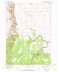
1968 Map of Little Honey Creek
USGS Topo · Published 1972About this map
Abert Rim dominates the western edge of this landscape, its sharp escarpment dropping toward the valley floor while the interior plateau is defined by the high-elevation drainage of Honey Creek and its tributaries. Significant historical markers are preserved here, most notably the Fort Warner (Site) near the confluence of Honey Creek and Deadman Creek, and a group of Petroglyphs located to the north. The area shows a specialized upland economy within the Fremont National Forest, with Chandler Cabin and several borrow pits scattered near jeep trails. Water sources are critical in this terrain, ranging from the White Pine Marsh and Fitzgerald Reservoir to remote points like O'Hallihan Spring and Vee Lake. A Lookout Tower on a high point south of Grouse Flat suggests the ongoing importance of fire observation during the late 1960s.
Find a feature on this map
30 named features on this map. Tap any name to fly to it.
Don’t see what you’re looking for? This feature index may not catch every label — zoom into the map to look around manually.
Map Details
Editions of this 1968 Little Honey Creek Map
This is the sole edition of this map. No revisions or reprints were ever made.
Other maps of this area

1955 · Klamath Falls
USGS Topo · 1:250,000

1958 · Klamath Falls
USGS Topo · 1:250,000

1964 · Crooked Creek Valley
USGS Topo · 1:24,000

1964 · Valley Falls
USGS Topo · 1:24,000

1966 · Coglan Buttes SE
USGS Topo · 1:24,000

1968 · Crook Peak
USGS Topo · 1:24,000
1968 · Drake Peak NE
USGS Topo · 1:24,000

1968 · Lake Abert South
USGS Topo · 1:24,000
1968 · Cooper Draw
USGS Topo · 1:24,000
1968 · Drake Peak
USGS Topo · 1:24,000