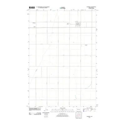
2011 Map of Cogswell
USGS Topo · Published 2011About this map
Cogswell stands as the primary hub of this prairie landscape, situated near the headwaters and drainage systems of the Wild Rice River. The town's grid is clearly defined by local thoroughfares such as Prospect Ave, 1st Ave, and 2nd Ave, reflecting a settled agricultural community in Sargent County. Outside the town center, the map documents several distinct burial sites that offer critical clues for genealogical research, including Mount Calvary Cemetery just west of the village and the Old Sargent Cemetery to the southeast. To the northwest, the small settlement of Nicholson is accompanied by its own Nicholson Cemetery, illustrating the early 20th-century pattern of localized farming communities. The landscape is also marked by early engineering efforts to manage the plains' hydrology, most notably through Ditch Number 11, which cuts through the western sections of the quadrangle.
Find a feature on this map
30 named features on this map. Tap any name to fly to it.
Don’t see what you’re looking for? This feature index may not catch every label — zoom into the map to look around manually.
Map Details
Editions of this 2011 Cogswell Map
This is the sole edition of this map. No revisions or reprints were ever made.
Other maps of this area

1952 · Crete
USGS Topo · 1:24,000

1953 · Kidder
USGS Topo · 1:24,000

1953 · Newark
USGS Topo · 1:24,000

1953 · Milbank
USGS Topo · 1:250,000

1953 · Fargo
USGS Topo · 1:250,000

1956 · Fargo
USGS Topo · 1:250,000
1956 · Straubville
USGS Topo · 1:24,000

1956 · Newark NW
USGS Topo · 1:24,000

1957 · Stirum
USGS Topo · 1:24,000

1957 · Cogswell
USGS Topo · 1:24,000