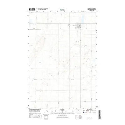
2014 Map of Cogswell
USGS Topo · Published 2014About this map
Cogswell serves as the primary hub of activity in this part of Sargent County, situated at the intersection of ND-11 and several local avenues. The landscape is defined by the subtle drainage patterns of the Wild Rice River in the southeast and the expansive Meszaros Slough to the west. This survey provides valuable data for genealogists, as it identifies three distinct burial sites: Mt Calvary Cem on the outskirts of Cogswell, the Old Sargent Cem further east, and the Nicholson Cem near the smaller settlement of Nicholson. The grid of section roads and the presence of Ditch Number 11 illustrate the systematic agricultural development of the North Dakota prairie, where water management is essential to the local economy.
Find a feature on this map
35 named features on this map. Tap any name to fly to it.
Don’t see what you’re looking for? This feature index may not catch every label — zoom into the map to look around manually.
Map Details
Editions of this 2014 Cogswell Map
This is the sole edition of this map. No revisions or reprints were ever made.
Other maps of this area

1952 · Crete
USGS Topo · 1:24,000

1953 · Kidder
USGS Topo · 1:24,000

1953 · Newark
USGS Topo · 1:24,000

1953 · Milbank
USGS Topo · 1:250,000

1953 · Fargo
USGS Topo · 1:250,000

1956 · Fargo
USGS Topo · 1:250,000
1956 · Straubville
USGS Topo · 1:24,000

1956 · Newark NW
USGS Topo · 1:24,000

1957 · Stirum
USGS Topo · 1:24,000

1957 · Cogswell
USGS Topo · 1:24,000