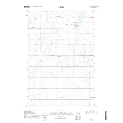
2020 Map of Cogswell
USGS Topo · Published 2020About this map
Cogswell stands as the primary hub in this Sargent County landscape, characterized by a structured grid of streets including Prospect Ave and several numbered avenues. The surrounding prairie is defined by its water management and agricultural layout, featuring Ditch Number 11 and the winding course of the Wild Rice River in the southeast. For genealogists and local historians, several burial sites are documented across the township lines, including Mount Calvary Cem just west of the main townsite, Nicholson Cem near the settlement of Nicholson, and the more isolated Old Sargent Cem to the east. The terrain is marked by numerous seasonal wetlands such as Meszaros Slough, illustrating the hydrologic complexity of the Red River Valley region. This survey captures the enduring rural character of the area, where section-line roads like Co Rd 3 and 90th St SE provide the framework for the modern North Dakota countryside.
Find a feature on this map
39 named features on this map. Tap any name to fly to it.
Don’t see what you’re looking for? This feature index may not catch every label — zoom into the map to look around manually.
Map Details
Editions of this 2020 Cogswell Map
This is the sole edition of this map. No revisions or reprints were ever made.
Other maps of this area

1952 · Crete
USGS Topo · 1:24,000

1953 · Kidder
USGS Topo · 1:24,000

1953 · Newark
USGS Topo · 1:24,000

1953 · Milbank
USGS Topo · 1:250,000

1953 · Fargo
USGS Topo · 1:250,000

1956 · Fargo
USGS Topo · 1:250,000
1956 · Straubville
USGS Topo · 1:24,000

1956 · Newark NW
USGS Topo · 1:24,000

1957 · Stirum
USGS Topo · 1:24,000

1957 · Cogswell
USGS Topo · 1:24,000