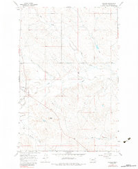
1965 Map of Cohagen
USGS Topo · Published 1984About this map
Cohagen sits as the central settlement in this mid-1960s survey of Garfield County, Montana. The landscape is defined by an intricate network of seasonal drainages, including Red Horse Creek, White Horse Creek, and Hay Creek, which carve through the high plains. Local history and genealogy are anchored at the Cohagen Cem northwest of the main cluster of buildings, while the broader terrain is marked by prominent landmarks like Phillips Buttes. The infrastructure reflects the area's mid-century isolation and agricultural utility, featuring a remote Landing Strip and the aptly named Graveyard Creek. Long-distance travel through this part of the Big Sky Country was facilitated by simple ranch roads, specifically identified as Two Furrow Road in the northern reaches, emphasizing the sparse, rugged character of the northern Missouri Plateau before modern highway development.
Find a feature on this map
16 named features on this map. Tap any name to fly to it.
Don’t see what you’re looking for? This feature index may not catch every label — zoom into the map to look around manually.
Map Details
Editions of this 1965 Cohagen Map
2 editions found
Other maps of this area

1954 · Jordan
USGS Topo · 1:250,000

1954 · Forsyth
USGS Topo · 1:250,000

1956 · Jordan
USGS Topo · 1:250,000

1957 · Forsyth
USGS Topo · 1:250,000

1958 · Jordan
USGS Topo · 1:250,000

1958 · Forsyth
USGS Topo · 1:250,000

1964 · Jordan
USGS Topo · 1:250,000

1965 · Black Hills
USGS Topo · 1:24,000

1965 · Cohagen
USGS Topo · 1:24,000

1965 · Calamity Coulee
USGS Topo · 1:24,000