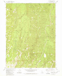
1979 Map of Cohasset
USGS Topo · Published 1980About this map
Musty Buck Ridge and Cohasset Ridge define the vertical character of this landscape in the late 1970s, where small settlements cling to high ground between steep drainages. The community of Cohasset serves as a focal point, supported by local infrastructure like the Cohasset Com and the Cohasset Forest Fire Sta. To the north, the boundary of the Lassen National Forest meets the Tehama Co Butte Co line, indicating a transition into more protected timberlands.
Find a feature on this map
49 named features on this map. Tap any name to fly to it.
Don’t see what you’re looking for? This feature index may not catch every label — zoom into the map to look around manually.
Map Details
Editions of this 1979 Cohasset Map
4 editions found
Other maps of this area

1886 · Lassen Peak
USGS Topo · 1:250,000

1891 · Chico
USGS Topo · 1:125,000

1892 · Lassen Peak
USGS Topo · 1:250,000

1893 · Chico
USGS Topo · 1:125,000

1894 · Lassen Peak
USGS Topo · 1:250,000

1895 · Chico
USGS Topo · 1:125,000

1912 · Keefers
USGS Topo · 1:31,680

1935 · Paynes Creek
USGS Topo · 1:96,000

1941 · Mineral
USGS Topo · 1:125,000

1944 · Richardson Springs
USGS Topo · 1:62,500