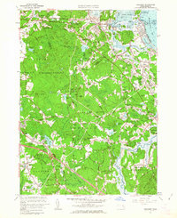
1961 Map of Cohasset
USGS Topo · Published 1963About this map
Scituate Harbor and Cohasset Harbor define the jagged coastline of the South Shore in the early 1960s, showing a landscape where coastal resorts and historical homesteads meet expanding suburban neighborhoods. The map highlights the Old Oaken Bucket Homestead and Old Oaken Bucket Pond, sites famously associated with the 19th-century poem by Samuel Woodworth. Inland, the transition from maritime activity to rural residential life is visible in the network of family-named crossroads like Clapps Corner and Mungo Corner. Large swaths of land remain dedicated to public and institutional use, including the US Government Reservation and the Glastonbury Monastery near Turkey Hill. The transportation landscape is anchored by the New York New Haven and Hartford railroad line and the prominent path of the Pilgrims Highway, illustrating the region's accessibility as it grew beyond its traditional fishing and farming roots.
Find a feature on this map
147 named features on this map. Tap any name to fly to it.
Don’t see what you’re looking for? This feature index may not catch every label — zoom into the map to look around manually.
Map Details
Editions of this 1961 Cohasset Map
2 editions found
Other maps of this area

1885 · Abington
USGS Topo · 1:62,500

1885 · Duxbury
USGS Topo · 1:62,500

1888 · Duxbury
USGS Topo · 1:62,500

1888 · Abington
USGS Topo · 1:62,500

1892 · Boston Bay
USGS Topo · 1:62,500

1893 · Abington
USGS Topo · 1:62,500

1893 · Duxbury
USGS Topo · 1:62,500

1903 · Boston Bay
USGS Topo · 1:62,500

1918 · Duxbury
USGS Topo · 1:62,500

1920 · Abington
USGS Topo · 1:62,500