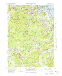
1974 Map of Cohasset
USGS Topo · Published 1978About this map
Cohasset Harbor and its surrounding rocky coastline define this mid-1970s coastal study, which includes the complex estuaries of The Gulf and Little Harbor. The map highlights a landscape of significant institutional and recreational preservation, from the sprawling Wompatuck State Park and Whitney Woods to the Glastonbury Monastery and Maryknoll Seminary. The settlement pattern shows traditional village centers like Beechwood, North Scituate, and Greenbush connected by the Penn Central rail line. Of particular interest to local historians is the Old Oaken Bucket Pond and the Cushing Memorial State Park near the North River. The terrain is punctuated by numerous family-named landmarks such as Cuffey Hill, Booth Hill, and James Hill, illustrating the enduring local geography of this South Shore region.
Find a feature on this map
201 named features on this map. Tap any name to fly to it.
Don’t see what you’re looking for? This feature index may not catch every label — zoom into the map to look around manually.
Map Details
Editions of this 1974 Cohasset Map
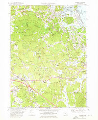
2 editions found
Other maps of this area

1885 · Abington
USGS Topo · 1:62,500

1885 · Duxbury
USGS Topo · 1:62,500

1888 · Duxbury
USGS Topo · 1:62,500

1888 · Abington
USGS Topo · 1:62,500

1892 · Boston Bay
USGS Topo · 1:62,500

1893 · Abington
USGS Topo · 1:62,500

1893 · Duxbury
USGS Topo · 1:62,500

1903 · Boston Bay
USGS Topo · 1:62,500

1918 · Duxbury
USGS Topo · 1:62,500

1920 · Abington
USGS Topo · 1:62,500