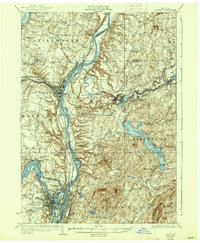
1929 Map of Cohoes
USGS Topo · Published 1937About this map
Bemis Heights Battlefield stands as a prominent historical landmark in the northern reach of this 1920s survey, marking a landscape defined by the convergence of the Hudson River and its major industrial tributaries. The engineering of the Barge Canal is meticulously documented as it bypasses the river's natural bends near Stillwater and Mechanicville, reflecting the critical role of water-borne commerce and power in the early 20th century. To the east, the Tomhannock Reservoir dominates the terrain of Pittstown, while the winding Hoosic River supports the manufacturing centers of Valley Falls and Johnsonville. A dense network of schools, including School No 4 and School No 1, and transport hubs like Stillwater Center Sta reveal the settled, community-focused character of the region during this period of New York's development.
Find a feature on this map
76 named features on this map. Tap any name to fly to it.
Don’t see what you’re looking for? This feature index may not catch every label — zoom into the map to look around manually.
Map Details
Editions of this 1929 Cohoes Map
4 editions found

Other maps of this area

1888 · Berlin
USGS Topo · 1:62,500

1890 · Berlin
USGS Topo · 1:62,500

1893 · Cohoes
USGS Topo · 1:62,500

1893 · Troy
USGS Topo · 1:62,500

1893 · Schenectady
USGS Topo · 1:62,500

1893 · Albany
USGS Topo · 1:62,500

1894 · Berlin
USGS Topo · 1:62,500

1895 · Troy
USGS Topo · 1:62,500

1895 · Cohoes
USGS Topo · 1:62,500

1895 · Albany
USGS Topo · 1:62,500