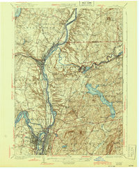
1929 Map of Cohoes
USGS Topo · Published 1943About this map
Saratoga Battlefield and the heights above the Hudson River dominate this survey, marking a landscape defined by Revolutionary War history and early 20th-century industrial transit. The confluence of the Hoosic River and the Hudson is a hub of activity, with the Barge Canal system cutting through older riverbeds and the Boston and Maine RR following the water level. The transition from industrial centers like Cohoes and Troy to the rural uplands of Easton and Pittstown is clearly visible, punctuated by numerous district schools such as School No 14 and School No 5. Insights into the era’s changing technology are found in the mapping of the Hudson Valley Electric RR (Abandoned) and the Schenectady Railway Co (Abandoned), documenting the decline of the interurban electric lines. From the spray of Cohoes Falls to the high ground of Mt Rafinesque, the map captures a pivotal moment when historic river towns were adapting to modern power and transportation networks.
Find a feature on this map
76 named features on this map. Tap any name to fly to it.
Don’t see what you’re looking for? This feature index may not catch every label — zoom into the map to look around manually.
Map Details
Editions of this 1929 Cohoes Map
4 editions found

Other maps of this area

1888 · Berlin
USGS Topo · 1:62,500

1890 · Berlin
USGS Topo · 1:62,500

1893 · Cohoes
USGS Topo · 1:62,500

1893 · Troy
USGS Topo · 1:62,500

1893 · Schenectady
USGS Topo · 1:62,500

1893 · Albany
USGS Topo · 1:62,500

1894 · Berlin
USGS Topo · 1:62,500

1895 · Troy
USGS Topo · 1:62,500

1895 · Cohoes
USGS Topo · 1:62,500

1895 · Albany
USGS Topo · 1:62,500