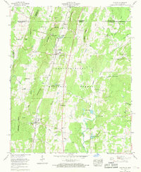
1960 Map of Cohutta
USGS Topo · Published 1970About this map
The Southern railroad line serves as a central spine through this north Georgia landscape, connecting the agricultural and small-town centers of Cohutta and Varnell. This 1960s-era geography reveals a rural economy shaped by water and timber, with the Chattahoochee National Forest covering much of the eastern terrain. The presence of Prater Mill along Coahulla Creek highlights the area's milling history, while the Cohutta National Fish Hatchery represents a specialized federal footprint near the Tennessee border. Local life is anchored by family-named landmarks and rural gathering places such as Gobblers Knob Ch, Mt Olivet Cem, and the McGaughey Lookout Tower. Scattered settlements like Red Clay and Plainview are mapped alongside numerous springs and ridges, illustrating the transition from the valley floor to the wooded highlands of Stancil Ridge and Lyles Ridge.
Find a feature on this map
73 named features on this map. Tap any name to fly to it.
Don’t see what you’re looking for? This feature index may not catch every label — zoom into the map to look around manually.
Map Details
Editions of this 1960 Cohutta Map
3 editions found
Other maps of this area

1886 · Dalton
USGS Topo · 1:125,000

1886 · Cleveland
USGS Topo · 1:125,000

1886 · Ringgold
USGS Topo · 1:125,000

1888 · Chattanooga
USGS Topo · 1:125,000

1892 · Ringgold
USGS Topo · 1:125,000

1892 · Cleveland
USGS Topo · 1:125,000

1892 · Dalton
USGS Topo · 1:125,000

1893 · Chattanooga
USGS Topo · 1:125,000

1895 · Cleveland
USGS Topo · 1:125,000

1897 · Dalton
USGS Topo · 1:125,000