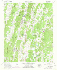
1960 Map of Cohutta
USGS Topo · Published 1975About this map
The Tennessee Valley floor and the rising slopes of the Chattahoochee National Forest define this area along the Georgia-Tennessee state line. Settled communities like Cohutta and Varnell are connected by the Southern Railway, which cuts through the terrain at White Cut and Masters Cut. Local history is visible in the network of country churches and burial grounds, such as Mt Olivet Cem and Gobblers Knob Ch. The map highlights the specialized use of the local watershed, featuring the Cohutta National Fish Hatchery and several springs like Varnell Spring and Sand Spring. Further south, the iconic Prater Mill sits along the winding path of Coahulla Creek, a testament to the rural industry that once centered on the region's abundant water power.
Find a feature on this map
72 named features on this map. Tap any name to fly to it.
Don’t see what you’re looking for? This feature index may not catch every label — zoom into the map to look around manually.
Map Details
Editions of this 1960 Cohutta Map
3 editions found
Other maps of this area

1886 · Dalton
USGS Topo · 1:125,000

1886 · Cleveland
USGS Topo · 1:125,000

1886 · Ringgold
USGS Topo · 1:125,000

1888 · Chattanooga
USGS Topo · 1:125,000

1892 · Ringgold
USGS Topo · 1:125,000

1892 · Cleveland
USGS Topo · 1:125,000

1892 · Dalton
USGS Topo · 1:125,000

1893 · Chattanooga
USGS Topo · 1:125,000

1895 · Cleveland
USGS Topo · 1:125,000

1897 · Dalton
USGS Topo · 1:125,000