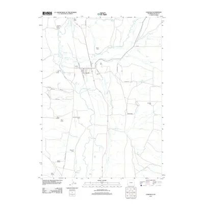
2012 Map of Cokeville
USGS Topo · Published 2012About this map
The Bear River meanders through this high-altitude landscape where the agricultural life of western Lincoln County is written into the land through an intricate network of irrigation. Settled near the confluence of the river and Smiths Fork, the town of Cokeville serves as a primary hub, while the small settlement of Pixley lies to the south near the Cokeville-Utah Line. The map reveals the critical importance of water rights in this arid environment, documenting named infrastructure like the Covey Canal, Mau Ditch, and the Stoner Nelson Wheelock Ditch. Historical movement through the region is marked by the Emigrant Trl, which cuts across the eastern flats near Stoffer Ridge. From the Cokeville Cem to the Cokeville Municipal Airport, the map provides a clear record of local genealogy and civil development in a terrain defined by named draws and hollows like Windmill Draw and Dry Hollow.
Find a feature on this map
60 named features on this map. Tap any name to fly to it.
Don’t see what you’re looking for? This feature index may not catch every label — zoom into the map to look around manually.
Map Details
Editions of this 2012 Cokeville Map
This is the sole edition of this map. No revisions or reprints were ever made.
Other maps of this area

1909 · Montpelier
USGS Topo · 1:125,000

1911 · Montpelier
USGS Topo · 1:125,000

1912 · Randolph
USGS Topo · 1:125,000

1936 · Cokeville
USGS Topo · 1:96,000

1942 · Cokeville
USGS Topo · 1:125,000

1954 · Sage
USGS Topo · 1:62,500

1954 · Ogden
USGS Topo · 1:250,000

1955 · Preston
USGS Topo · 1:250,000

1958 · Ogden
USGS Topo · 1:250,000

1958 · Preston
USGS Topo · 1:250,000