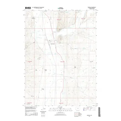
2015 Map of Cokeville
USGS Topo · Published 2015About this map
The town of Cokeville serves as the hub of this high-desert basin, where the Smiths Fork and S Fork Smiths Fork converge before joining the Bear River. This 2015 survey reveals a complex network of agricultural irrigation, with numerous man-made channels such as the Covey Canal, Mau Ditch, and Pixley Ditch diverting water across the valley floor. To the east, the terrain rises sharply toward Big Hill and Stoffer Ridge, while the western flats accommodate the Cokeville Municipal Airport. Traces of the region's western heritage are visible in the historic Emigrant Trl, which skirts the eastern foothills near Larson Reservoir. The landscape is further defined by numerous draws and hollows, including Boyd Hollow and Windmill Draw, illustrating the relationship between the rugged topography and the essential water management systems that support life in this corner of Lincoln County.
Find a feature on this map
58 named features on this map. Tap any name to fly to it.
Don’t see what you’re looking for? This feature index may not catch every label — zoom into the map to look around manually.
Map Details
Editions of this 2015 Cokeville Map
This is the sole edition of this map. No revisions or reprints were ever made.
Other maps of this area

1909 · Montpelier
USGS Topo · 1:125,000

1911 · Montpelier
USGS Topo · 1:125,000

1912 · Randolph
USGS Topo · 1:125,000

1936 · Cokeville
USGS Topo · 1:96,000

1942 · Cokeville
USGS Topo · 1:125,000

1954 · Sage
USGS Topo · 1:62,500

1954 · Ogden
USGS Topo · 1:250,000

1955 · Preston
USGS Topo · 1:250,000

1958 · Ogden
USGS Topo · 1:250,000

1958 · Preston
USGS Topo · 1:250,000