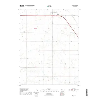
2018 Map of Colby SE
USGS Topo · Published 2018About this map
The Colby cityscape gives way to the High Plains landscape of Thomas County in this 2018 survey, where the urban grid meets a vast network of section roads. Dominating the northern edge are local thoroughfares like Horton Ave, S Range Ave, and S Franklin Ave, which facilitate the movement of agricultural goods and commuters around the city center. South of the Interstate 70 corridor, the terrain is defined by the winding paths of the N Fork Solomon River and S Fork Solomon River, which carve through the plains. The map illustrates the structured land division of the region, from the residential streets of Maple St and Willow to the expansive township and range boundaries of t8s r34w, t8s r33w, and t9s r34w. This record preserves the intersection of modern transportation infrastructure and the natural drainage systems of the Solomon River forks.
Find a feature on this map
29 named features on this map. Tap any name to fly to it.
Don’t see what you’re looking for? This feature index may not catch every label — zoom into the map to look around manually.
Map Details
Editions of this 2018 Colby SE Map
This is the sole edition of this map. No revisions or reprints were ever made.
Other maps of this area

1943 · Colby
USGS Topo · 1:62,500

1954 · Goodland
USGS Topo · 1:250,000

1956 · Goodland
USGS Topo · 1:250,000

1957 · Goodland
USGS Topo · 1:250,000

1967 · Colby SE
USGS Topo · 1:24,000

1967 · Levant
USGS Topo · 1:24,000

1967 · Colby SW
USGS Topo · 1:24,000

1967 · Colby
USGS Topo · 1:24,000

1972 · Winona NE
USGS Topo · 1:24,000
1972 · Winona NW
USGS Topo · 1:24,000