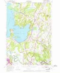
1948 Map of Colchester
USGS Topo · Published 1973About this map
Malletts Bay dominates this mid-century survey, its coastline dotted with seasonal landmarks and established orchards. The landscape reflects a mix of traditional agriculture and emerging infrastructure, from the Winnisquam Orchard and Town Farm to the more modern presence of Ethan Allen Air Force Base near Winooski. Transportation and recreation are central to the area's layout, featuring a Drag Strip and a Drive-in Theater alongside older institutional markers like School No 3 and School No 4. The Central Vermont railroad cuts a north-south path through the hills, passing below Cobble Hill and connecting the rural outskirts of Colchester with the industrial fringes of Burlington. Several distinct summer camps, including Camp Kiniya and Camp Norfleet, line the shores of Lake Champlain, illustrating the region's long-standing appeal as a retreat.
Find a feature on this map
54 named features on this map. Tap any name to fly to it.
Don’t see what you’re looking for? This feature index may not catch every label — zoom into the map to look around manually.
Map Details
Editions of this 1948 Colchester Map
4 editions found

Other maps of this area

1894 · Plattsburg
USGS Topo · 1:62,500

1895 · Willsboro
USGS Topo · 1:62,500

1906 · Plattsburg
USGS Topo · 1:62,500

1906 · Burlington
USGS Topo · 1:62,500

1913 · Milton
USGS Topo · 1:48,000

1915 · Milton
USGS Topo · 1:62,500

1919 · Burlington
USGS Topo · 1:62,500

1939 · Plattsburg
USGS Topo · 1:62,500

1941 · Plattsburg
USGS Topo · 1:62,500

1941 · Willsboro
USGS Topo · 1:62,500