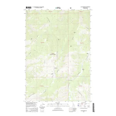
2017 Map of Cold Meadows
USGS Topo · Published 2017About this map
Payette National Forest encompasses this wilderness landscape, where the high-elevation basin of Cold Meadows serves as a central landmark. The presence of the Cold Meadows USFS Airport indicates the importance of aerial access in managing these remote interior reaches. The terrain is defined by a series of prominent ridges and peaks, including Roots Knob, Dismal Mtn, and the high reaches of Grass Mountain (Wilderness). Drainage patterns are complex, with various branches of Cottonwood Creek and Whimstick Creek carving through the slopes. This area represents a preserved wilderness environment, largely devoid of road infrastructure, where traditional names like Frog Spring Ridge/Club Meadows and Runaway Point hint at the historical usage of the land by foresters and early backcountry travelers.
Find a feature on this map
37 named features on this map. Tap any name to fly to it.
Don’t see what you’re looking for? This feature index may not catch every label — zoom into the map to look around manually.
Map Details
Editions of this 2017 Cold Meadows Map
This is the sole edition of this map. No revisions or reprints were ever made.
Other maps of this area

1956 · Elk City
USGS Topo · 1:250,000

1960 · Elk City
USGS Topo · 1:250,000

1962 · Vinegar Hill
USGS Topo · 1:24,000

1962 · Papoose Peak
USGS Topo · 1:24,000

1973 · Acorn Butte
USGS Topo · 1:24,000

1977 · Cottonwood Butte
USGS Topo · 1:24,000

1978 · Waugh Mountain
USGS Topo · 1:24,000

1978 · Arctic Point
USGS Topo · 1:24,000

1978 · Wapiti Creek
USGS Topo · 1:24,000

1978 · Devils Teeth Rapids
USGS Topo · 1:24,000