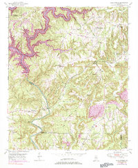
1949 Map of Cold Springs
USGS Topo · Published 1984About this map
Deep creek valleys and high ridge-lines define this Alabama landscape where the boundaries of Winston, Cullman, and Walker counties meet. The settlement of Cold Springs, also serving as the Bremen Post Office, acts as a primary hub in an area marked by numerous country churches, including Addington Chapel, Sandlin Chapel, and McKinley Chapel.
Find a feature on this map
51 named features on this map. Tap any name to fly to it.
Don’t see what you’re looking for? This feature index may not catch every label — zoom into the map to look around manually.
Map Details
Editions of this 1949 Cold Springs Map
5 editions found
Other maps of this area

1888 · Cullman
USGS Topo · 1:125,000

1889 · Birmingham
USGS Topo · 1:125,000

1892 · Cullman
USGS Topo · 1:125,000

1892 · Birmingham
USGS Topo · 1:125,000

1893 · Jasper
USGS Topo · 1:125,000

1895 · Birmingham
USGS Topo · 1:125,000

1907 · Birmingham
USGS Topo · 1:125,000

1949 · Cordova
USGS Topo · 1:24,000

1949 · Sipsey
USGS Topo · 1:24,000

1949 · Cold Springs
USGS Topo · 1:24,000