
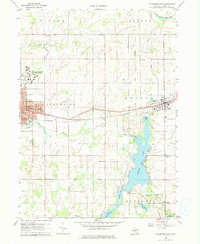
1960 Map of Coldwater East
USGS Topo · Published 1961About this map
Coldwater serves as a regional anchor on this 1960 survey, defined by its intricate street grid featuring Chicago St and the extensive grounds of the Coldwater State Home and Training School. The landscape transitions from the urban center to a complex water system dominated by Marble Lake and a chain of smaller bodies including First Lake, Middle Lake, and Archer Lake. This hydrological network is linked by the East Branch Coldwater River, illustrating how local topography shaped early settlement and recreation patterns in Branch County.
Find a feature on this map
50 named features on this map. Tap any name to fly to it.
Don’t see what you’re looking for? This feature index may not catch every label — zoom into the map to look around manually.
Map Details
Editions of this 1960 Coldwater East Map
2 editions found
Other maps of this area

1918 · Union City
USGS Topo · 1:62,500

1947 · Union City
USGS Topo · 1:62,500

1948 · Homer
USGS Topo · 1:62,500

1949 · Homer
USGS Topo · 1:62,500

1950 · Union City
USGS Topo · 1:62,500

1953 · Fort Wayne
USGS Topo · 1:250,000

1956 · Fort Wayne
USGS Topo · 1:250,000

1958 · Grand Rapids
USGS Topo · 1:250,000

1960 · Coldwater West
USGS Topo · 1:24,000
1960 · Camden
USGS Topo · 1:24,000