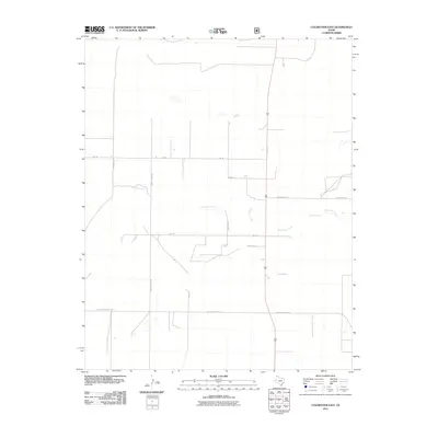
2011 Map of Coldwater East
USGS Topo · Published 2011About this map
Coldwater Creek meanders across this northern Texas Panhandle landscape, defining the hydrology of a region where water sources like Aqua Fria Spring were historically vital for cattle and early settlement. The map reveals a grid-like pattern of rural development, dominated by long-distance routes and localized farm roads. Significant thoroughfares like FM-296 and W High Lonesome Ln cut across the plains, while names like School House Rd and Minnie Mack Ln hint at the personal histories and community infrastructure of Dallam County. This 2011 survey captures the area’s character as a managed agricultural and ranching territory, where the intersection of natural drainage and systematic road planning, including Smith Ln and Sunnyspot Ln, facilitates life in a sparse, high-plains environment.
Find a feature on this map
14 named features on this map. Tap any name to fly to it.
Don’t see what you’re looking for? This feature index may not catch every label — zoom into the map to look around manually.
Map Details
Editions of this 2011 Coldwater East Map
This is the sole edition of this map. No revisions or reprints were ever made.
Other maps of this area

1954 · Dalhart
USGS Topo · 1:250,000

1958 · Dalhart
USGS Topo · 1:250,000

1962 · Dalhart
USGS Topo · 1:250,000

1969 · Boise City SW
USGS Topo · 1:24,000

1969 · Boise City SE
USGS Topo · 1:24,000

1971 · Conrad SW
USGS Topo · 1:24,000

1973 · Stratford 2 NW
USGS Topo · 1:24,000

1973 · Tovrea Ranch
USGS Topo · 1:24,000
1973 · Coldwater West
USGS Topo · 1:24,000

1973 · Coldwater East
USGS Topo · 1:24,000