
1973 Map of Stratford 2 NW
USGS Topo · Published 1975About this map
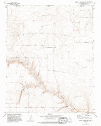
Coldwater Creek carves a deep, winding valley across this section of the High Plains, providing a stark topographical contrast to the surrounding tablelands. Recorded in the early 1970s, this landscape in northern Dallam County reflects a sparsely populated ranching environment near the Oklahoma-Texas border. The settlement of Sneed and the curiously named Lost Camp serve as primary human landmarks in a region defined by wide-open pastures and occasional resource exploration, evidenced by a remote Drill Hole in the northern portion of the quadrangle. The map captures the intersection of Cimarron and Dallam counties, illustrating how drainage patterns and property lines dictated the sparse development of this borderland territory before modern infrastructure further altered the terrain.
Find a feature on this map
6 named features on this map. Tap any name to fly to it.
Don’t see what you’re looking for? This feature index may not catch every label — zoom into the map to look around manually.
Map Details
Editions of this 1973 Stratford 2 NW Map
2 editions found
Other maps of this area

1954 · Dalhart
USGS Topo · 1:250,000

1958 · Dalhart
USGS Topo · 1:250,000

1962 · Dalhart
USGS Topo · 1:250,000

1964 · Stratford 2 SE
USGS Topo · 1:24,000

1964 · Stratford 2 NE
USGS Topo · 1:24,000

1969 · Boise City SE
USGS Topo · 1:24,000

1971 · Conrad SW
USGS Topo · 1:24,000
1971 · Conrad
USGS Topo · 1:24,000

1973 · Coldwater East
USGS Topo · 1:24,000
1973 · Pritchard Ranch
USGS Topo · 1:24,000