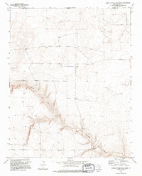
1973 Map of North of Red Cow Draw
USGS Topo · Published 1995About this map
Coldwater Creek carves a deep, winding path through the high plains of the Texas Panhandle in this early 1970s survey. The landscape is defined by the sharp contrast between the flat plateau and the intricate erosional drainage of the creek valley, which dominates the central and southern portions of the map. Scattered markers of human activity are sparse, primarily consisting of isolated points like Sneed and the cattle-camp reference of Lost Camp. Resource extraction and ranching infrastructure are noted through features such as a Drill Hole and a remote Well, reflecting the utilitarian nature of this borderland terrain. The map also delineates the high-latitude boundary between Oklahoma and Texas, along with the intersection of Cimarron and Dallam counties, making it a critical reference for understanding the precise geopolitical lines and sparse settlement patterns of this frontier region.
Find a feature on this map
7 named features on this map. Tap any name to fly to it.
Don’t see what you’re looking for? This feature index may not catch every label — zoom into the map to look around manually.
Map Details
Editions of this 1973 North of Red Cow Draw Map
2 editions found
Other maps of this area

1954 · Dalhart
USGS Topo · 1:250,000

1958 · Dalhart
USGS Topo · 1:250,000

1962 · Dalhart
USGS Topo · 1:250,000

1964 · Stratford 2 SE
USGS Topo · 1:24,000

1964 · Stratford 2 NE
USGS Topo · 1:24,000

1969 · Boise City SE
USGS Topo · 1:24,000

1971 · Conrad SW
USGS Topo · 1:24,000
1971 · Conrad
USGS Topo · 1:24,000

1973 · Stratford 2 NW
USGS Topo · 1:24,000

1973 · Coldwater East
USGS Topo · 1:24,000