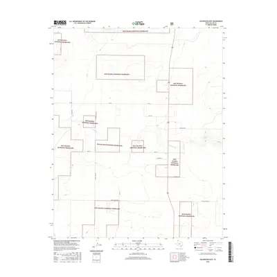
2016 Map of Coldwater East
USGS Topo · Published 2016About this map
Rita Blanca National Grassland dominates the landscape of this Dallam County survey, appearing in fractured blocks that illustrate the checkerboard patterns of public land management in the Texas Panhandle. The terrain is defined by the winding course of Coldwater Cr, which cuts through the high plains alongside the intermittent Aqua Fria Spring. This 2016 data reflects a modern rural infrastructure where the traditional cattle ranching economy is mapped through a grid of local roads and farm-to-market routes. Genealogists and local historians can trace family-named thoroughfares such as Minnie Mack Ln and French Rd, while the evocative W High Lonesome Ln captures the characteristic isolation of the Llano Estacado. The presence of School House Rd provides a geographic marker for former rural social centers in this sparsely populated cattle country.
Find a feature on this map
14 named features on this map. Tap any name to fly to it.
Don’t see what you’re looking for? This feature index may not catch every label — zoom into the map to look around manually.
Map Details
Editions of this 2016 Coldwater East Map
This is the sole edition of this map. No revisions or reprints were ever made.
Other maps of this area

1954 · Dalhart
USGS Topo · 1:250,000

1958 · Dalhart
USGS Topo · 1:250,000

1962 · Dalhart
USGS Topo · 1:250,000

1969 · Boise City SW
USGS Topo · 1:24,000

1969 · Boise City SE
USGS Topo · 1:24,000

1971 · Conrad SW
USGS Topo · 1:24,000

1973 · Stratford 2 NW
USGS Topo · 1:24,000

1973 · Tovrea Ranch
USGS Topo · 1:24,000
1973 · Coldwater West
USGS Topo · 1:24,000

1973 · Coldwater East
USGS Topo · 1:24,000