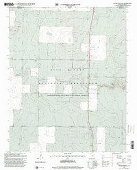
1998 Map of Coldwater East
USGS Topo · Published 2001About this map
Rita Blanca National Grassland dominates this high plains landscape along the border of the Texas Panhandle and Oklahoma. The area, located within Dallam County, shows a land defined by water management and conservation, with numerous wells and several instances of Gravel Pits distributed across the terrain. The presence of Coldwater and the eponymous Coldwater Creek indicates the importance of these drainage systems in an otherwise arid environment.
Find a feature on this map
11 named features on this map. Tap any name to fly to it.
Don’t see what you’re looking for? This feature index may not catch every label — zoom into the map to look around manually.
Map Details
Editions of this 1998 Coldwater East Map
This is the sole edition of this map. No revisions or reprints were ever made.
Other maps of this area

1954 · Dalhart
USGS Topo · 1:250,000

1958 · Dalhart
USGS Topo · 1:250,000

1962 · Dalhart
USGS Topo · 1:250,000

1969 · Boise City SW
USGS Topo · 1:24,000

1969 · Boise City SE
USGS Topo · 1:24,000

1971 · Conrad SW
USGS Topo · 1:24,000

1973 · Stratford 2 NW
USGS Topo · 1:24,000

1973 · Tovrea Ranch
USGS Topo · 1:24,000
1973 · Coldwater West
USGS Topo · 1:24,000

1973 · Coldwater East
USGS Topo · 1:24,000