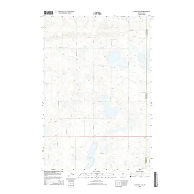
2014 Map of Coldwater Lake
USGS Topo · Published 2014About this map
Coldwater Lake anchors the southern landscape of this 2014 survey, a significant water body in the glacial prairie of southern North Dakota. The area is characterized by a grid of agricultural section roads including 63rd Ave SE and 94th St SE, which facilitate travel through the wetlands and prairie potholes common to this region. Traces of early settlement and family history are preserved at the Bertsch Cem in the west and the Cem of Salem near the eastern boundary. The map clearly delineates the Mcintosh Co Dickey Co line, providing a precise look at the jurisdictional division between these two counties. State highway ND-11 serves as the primary east-west corridor, cutting across a landscape dotted with unnamed marshes and small basins typical of the Missouri Coteau upland.
Find a feature on this map
19 named features on this map. Tap any name to fly to it.
Don’t see what you’re looking for? This feature index may not catch every label — zoom into the map to look around manually.
Map Details
Editions of this 2014 Coldwater Lake Map
This is the sole edition of this map. No revisions or reprints were ever made.
Other maps of this area

1896 · Edgeley
USGS Topo · 1:125,000

1899 · Ellendale
USGS Topo · 1:125,000

1925 · Edgeley
USGS Topo · 1:125,000

1953 · Jamestown
USGS Topo · 1:250,000

1954 · Aberdeen
USGS Topo · 1:250,000

1956 · Aberdeen
USGS Topo · 1:250,000

1956 · Jamestown
USGS Topo · 1:250,000

1968 · Long Lake NW
USGS Topo · 1:24,000

1968 · Long Lake NE
USGS Topo · 1:24,000
1968 · Forbes NW
USGS Topo · 1:24,000
Featured Places
- Spring Valley Township, ND
- German Township, ND
- Albertha Township, ND
- McIntosh County, ND
- Dickey County, ND